SANP Field Event
Indian Flat Waterfall Cascades & More
Saturday, October 29, 2022
Leader: Dale Potter Phone: (865)-773-8114 E-mail: dalepotter55@gmail.com
Meeting place: Middle Prong Trailhead on Upper Tremont Road in GSMNP
Time: 7:30 am
Registration available: Beginning today
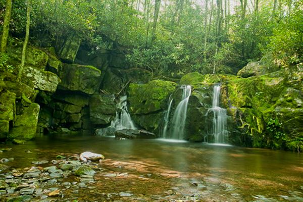
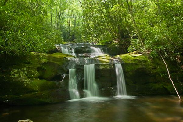
Description: Indian Flat Falls are not on the trail maps, but the falls are one of the more photographed falls in the smokies. It is a popular falls in the fall. The falls consist of four cascades. One is easily access by a short off trail, the others require a little more effort. This is an easy to moderate, 7.5 miles walk roundtrip on an old road bed up Middle Prong Trail. Elevation gain: 1100 feet. There are several other water options along the trail that you may want to photograph.
We will start at the end of Tremont Road where Old Tremont, the 1920s logging town, once stood. The Middle Prong Trail follows an old railroad grade along beautiful Lynn Camp Prong. In places the trail will be somewhat rocky. Panther Falls can be seen within the first mile. At 3.0 miles there's evidence of the old CCC dining hall and a furnace. Further up, the trail crosses Indian Flats Prong on a wide bridge. Less than half a mile up is a short side trail to Indian Flats Falls. We will follow a side trail about 150 feet to the uppermost falls. The side trail isn't marked. The first time I led a group to this location in 2010, I was told that the falls did not exist by another hike leader. Since then more people have discovered the falls, especially photographers. It is a great location to photograph from in the fall. Some of the better photos require you getting in the water. Four falls in all that drop 65 feet and run 170 feet.
Learning opportunities:
This is a good location to work on your technique for getting pleasing images of waterfalls and fast water.
How to meter for the best exposure
How to interpret the histogram for the best exposure.
What shutter speeds to use for the look you want
How to use polarizers and neutral density filters
Lenses of any focal length from 20mm to about 300mm will be useful. Tripod…..mandatory.
What to bring: Shoes that you are comfortable getting your feet wet in. You can change at the falls if you so desire but you may want to stop along the walk to the falls to get some other photos in the water.
Bring water and snacks.
An overcast day would be ideal for this trip. An early start allows us to get to the Falls without a bright sun.
Walking required: The trail is an easy to moderate 7.5 mile in and out trail. It is an old road bed for most of the way.
Bathroom is available at Tremont Institute if you want to stop before heading up the Upper Tremont Road.
Driving directions: From the intersection of Little River Road and Laurel Creek Road, go 0.2 miles toward Cades Cove and turn left at the Tremont sign. Follow Tremont Road, it will turn into a gravel road, follow it 3 miles until it ends at a turnaround. You can Google Middle Prong Trailhead, Townsend, Tn. I will be in a red Jeep Wrangler.